


Bud Dajo
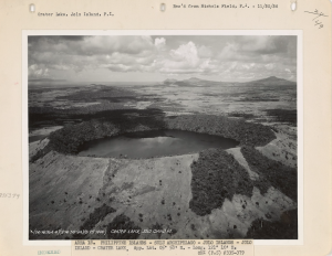
Bud Dajo Volcano is an active volcano on Jolo Island in the southwestern region of the Philippines. A basaltic cinder cone rising to an elevation of 660 meters above sea level, it is the second tallest among the over 20 mountain peaks on Jolo. The highest peak is Tumatangas Volcano, which reaches 790 meters and is classified as a potentially active volcano, one of five such volcanoes identified in the region. The island, which spans 60 kilometers in width, features numerous pyroclastic cones and crater lakes and is located at the southwestern tip of the Zamboanga Peninsula in Mindanao. Bud Dajo is part of the Sulu Archipelago, a linear arrangement of volcanic islands that extends southwest from the Zamboanga Peninsula and is geologically linked to the Sulu Arc, a volcanic chain formed by the subduction of the Sulu Sea crust beneath the Celebes Sea along the Sulu Trench.
Jolo Island is predominantly made up of basalts and basaltic andesites, which serves as clear evidence of its volcanic origins. However, there is a scarcity of information regarding the eruptive history of Bud Dajo. An eruption reported in 1641, previously thought to be associated with Bud Dajo, was actually the result of ash fall from Mount Melibengoy (formerly known as Parker Volcano) located in Mindanao. Additionally, a tsunami that occurred in 1897 was speculated to have been triggered by a submarine eruption, yet no definitive evidence of volcanic activity has been discovered. Due to the lack of unequivocal evidence to support more recent volcanic activity, the Smithsonian Institution’s Volcanoes of the World directory identifies Bud Dajo’s last eruption as having taken place sometime during the Pleistocene, a geological epoch that extended from approximately 2.6 million years ago to around 11,000 years ago. The discredited reports of historic eruptions of Bud Dajo in 1641 and 1897 render the local identification of Bud Dajo as an active volcano contentious.
Beyond its geological significance, Bud Dajo is historically known as the site of the Battle of Bud Dajo (also called the Bud Dajo Massacre), which took place in March 1906, during the American colonial period. Approximately 600 Moro men, women, and children—many of whom were non-combatants—were killed by U.S. Army forces under the command of General Leonard Wood, during an offensive ordered under President Theodore Roosevelt. The event remains one of the most infamous massacres in Philippine history and is a significant marker of Moro resistance against U.S. rule. Considered as a sacred mountain, Bud Dajo and the adjacent lands were declared as the Mount Dajo National Park on February 28, 1938 through Proclamation No. 261 under President Manuel L. Quezon.
Other Names: Bud dajo; Mount Dano; part of Jolo (group of) volcano[es)
Latitude and Longitude: 6.01293 121.05745
Region: Bangsamoro Autonomous Region in Muslim Mindanao (BARMM)
Tectonic Setting: Subduction Zone – Sulu Trench
Volcanic Arc/Belt: Sulu Arc
Volcanic Region/Field: Basilan VF
Volcano Type: Pyroclastic Cone / Basaltic Cinder Cone; Pleistocene
Last Known Eruption: 1897
Morphometry Type: Small Steep Cone
Highest Peak (masl): 650
Coordinates of Highest Peak: 6.01415 121.05572
Prominence (m): 332
Basal Area (km2): –
Basal Width (km): 1.85
Volume (km3): 0.25
How to cite this page:
UPRI (2025). Bud Dajo: Volcanoes of the Philippines (NOAH Open File Reports). Distributed by the University of the Philippines Resilience Institute, compiled by Lea Victoria D. Serrano. ISSN 2362 7409.
References:
Castillo, P. R., Solidum, R. U., & Punongbayan, R. S. (2002). Origin of high field strength element enrichment in the Sulu Arc, southern Philippines, revisited. Geology, 30(8), 707. https://doi.org/10.1130/0091-7613(2002)030%3C0707:oohfse%3E2.0.co;2
Google Maps. (n.d.). Bud Dajo · Patikul, Sulu, Philippines. Bud Dajo · Patikul, Sulu, Philippines. Retrieved July 29, 2024, from https://www.google.com/maps/place/Bud+Dajo/
Masó, M. S. (1904). Volcanoes and Seismic Centers of the Philippine Archipelago. https://archive.org/details/volcanoesandsei00masgoog/page/n19/mode/2up?ref=ol&view=theater&q=jolo
Mountain Forecast. (n.d.). Bud Dajo Mountain Information. Www.mountain-Forecast.com. Retrieved July 29, 2024, from https://www.mountain-forecast.com/peaks/Bud-Dajo
National Mapping and Resource Information Authority. (n.d.). 1:50,000 Scale Danag Map. Namria.gov.ph. https://namria.gov.ph/downloads/topomap50/3238-IIIDanagPatikul.jpg
Paguican, E. M., Grosse, P., Fabbro, G. N., & Kervyn, M. (2021). Morphometric classification and spatial distribution of Philippine volcanoes. Journal of Volcanology and Geothermal Research, 418, 107251. https://doi.org/10.1016/j.jvolgeores.2021.107251
Pfeiffer, T. (2020). Jolo. Volcanodiscovery.com. https://www.volcanodiscovery.com/jolo.html
PHIVOLCS. (2007). Jolo, Sulu Tsunami Hazard Map. https://gisweb.phivolcs.dost.gov.ph/gisweb/storage/hazard-maps/autonomous-region-in-muslim-mindanao-(armm)/sulu/jolo-(capital)/earthquake/tsunami/tsu_2007_156602000_01.jpg
/sulu/jolo-(capital)/earthquake/tsunami/tsu_2007_156602000_01.jpg)
PHIVOLCS. (2016). Volcanoes of the Philippines. Www.phivolcs.dost.gov.ph. https://www.phivolcs.dost.gov.ph/index.php/volcano-hazard/volcanoes-of-the-philippines
PHIVOLCS. (2023). VMEPD: Eruption History. Dost.gov.ph. https://vmepd.phivolcs.dost.gov.ph/volcan/erupt-history?volcan=29&sdate=&edate=&btn-search=
Proclamation No. 261, s. 1938. (1938, February 28). Official Gazette of the Republic of the Philippines. Retrieved from https://lawphil.net/executive/proc/proc1938/proc_261_1938.html
Salonga, N., & Bayon, F. (1992). HYDROTHERMAL MODEL OF MT. PARKER, A QUATERNARY VOLCANO IN SOUTH COTABATO BASIN, MINDANAO ISLAND, PHILIPPINES. https://pangea.stanford.edu/ERE/pdf/IGAstandard/NZGW/1992/Salonga.pdf
Sajona, F., Maury, R., Bellon, H., Cotten, J., & Defant, M. (1996). High Field Strength Element Enrichment of Pliocene—Pleistocene Island Arc Basalts, Zamboanga Peninsula, Western Mindanao (Philippines). Journal of Petrology, 37(3), 693–726. https://doi.org/10.1093/petrology/37.3.693
Siebert, L., Simkin, T., & Kimberly, P. (2010). Volcanoes of the world. Smithsonian Institution ; Berkeley. https://www.geokniga.org/bookfiles/geokniga-volcanoes-world.pdf?fbclid=IwZXh0bgNhZW0CMTEAAR2D3TWGIhRNcOyPabm6jNJPmLq0RZPqXkDcNGOnkSSoJlXhHd95u3WKZ48_aem_K70-6lPk2ZrQWYz7wpZhMg
Smith, W. D., & Baker, W. D. (1908). A geologic reconnaissance of the Island of Mindanao and the Sulu Archipelago: I. Narrative of the expedition. Bureau of Science of the Philippine Government.
Smithsonian Institute. (2013). Global Volcanism Program | Jolo. Smithsonian Institution | Global Volcanism Program. https://volcano.si.edu/volcano.cfm?vn=270010
Wagner, K. (2024). Massacre in the clouds: An American atrocity and the erasure of history. Hachette UK. Retrieved from https://books.google.com.ph/books?hl=en&lr=&id=XCLVEAAAQBAJ