Written by Marc Forneste and Audrei Anne Ybanez of Hazard Assessment Team
In recent months, the Philippines has experienced heightened volcanic activity. Alert Levels remain elevated at several volcanoes: Mayon is at Alert Level 3, Kanlaon at Alert Level 2, and Taal at Alert Level 1, while Bulusan was de-escalated to Alert Level 0 on February 6, 2026. Although the near-simultaneous unrest across multiple volcanic centers may seem alarming, PHIVOLCS has clarified that these events are not causally related and should be treated as isolated processes driven by each volcano’s internal dynamics.
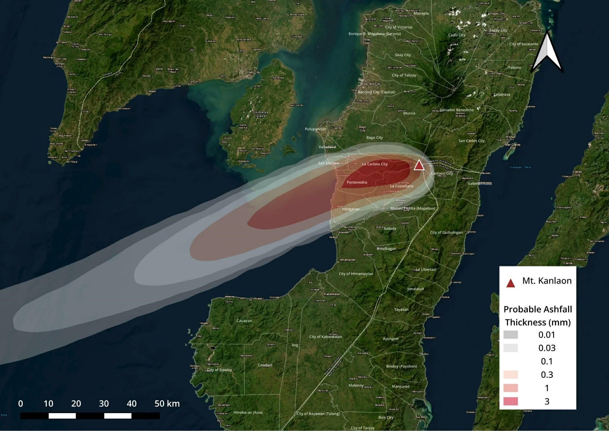
On February 19, 2026 at 4:39 PM (local time), a two-minute moderately explosive eruption occurred at Mount Kanlaon. According to PHIVOLCS and Tokyo VAAC, the event produced an ash plume rising approximately 2 kilometers above the vent, followed by an ash emission that lasted about 40 minutes. The plume drifted southwest, affecting several localities, including Bago City, Hinigaran, Valladolid, La Carlota, La Castellana, and Pontevedra.

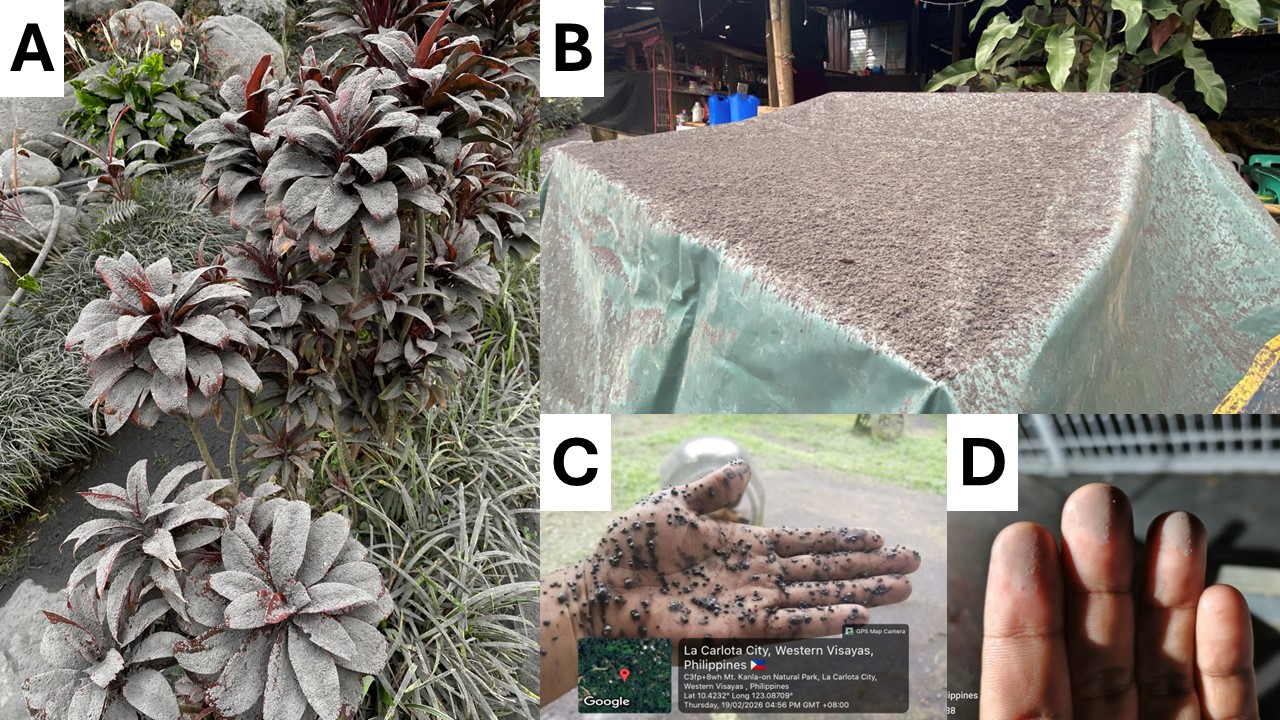
The eruption also generated pyroclastic density currents (PDCs) that traveled up to 1 kilometer downslope from the crater and extended more than 2 kilometers along the southwestern flank. Tephra fall was recorded in areas surrounding the volcano, particularly in downwind communities, Sulfurous fumes were likewise reported in several areas, including La Carlota City, Bago City, and Moises Padilla (PHIVOLCS, 2026).
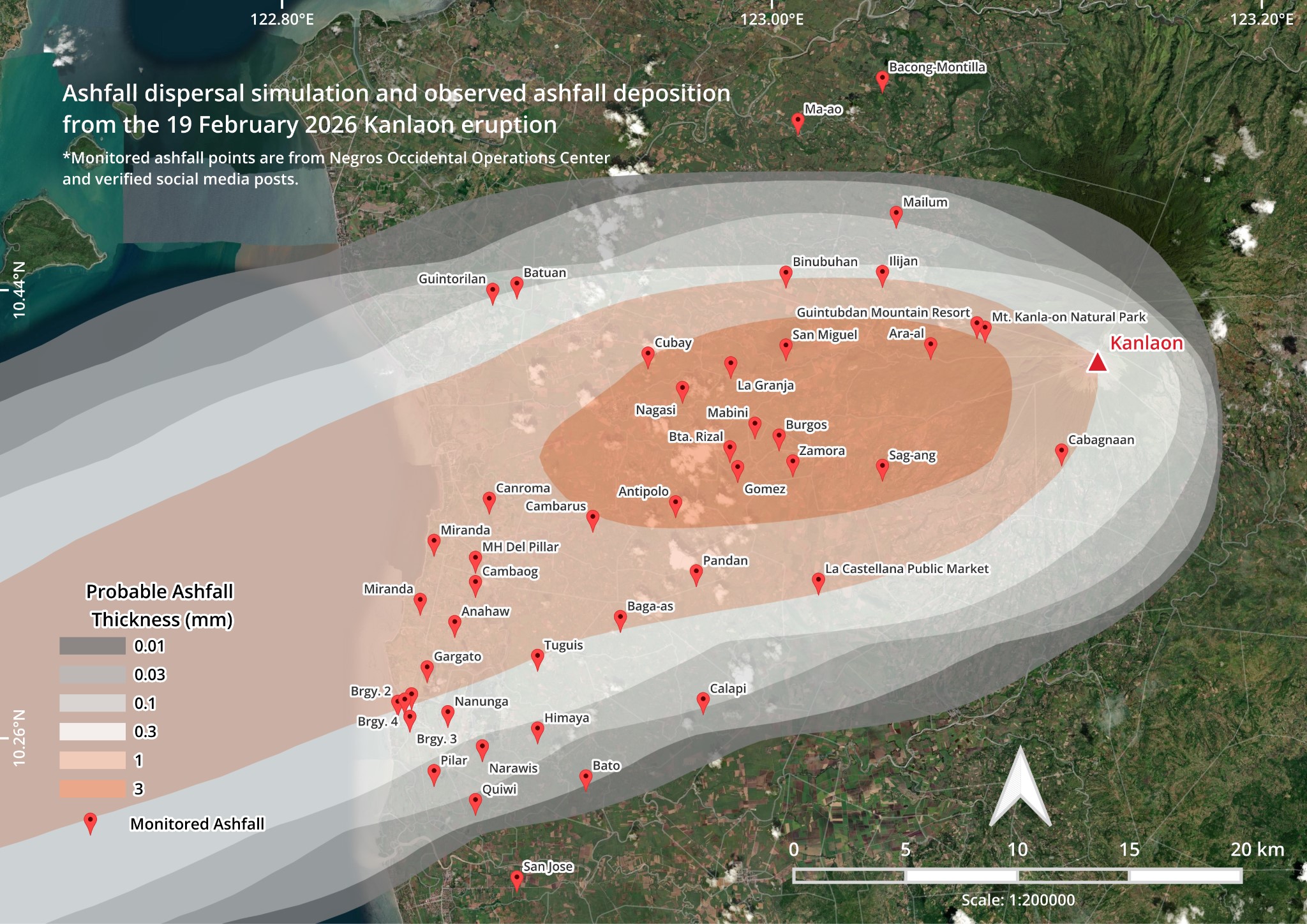
Researchers from the UP RI NOAH Center- Hazard Assessment Team simulated the eruption (Figure 2) using observed parameters released by PHIVOLCS and Tokyo VAAC through Ash3D, an open-source ash dispersion model developed by the United States Geological Survey (USGS). Results indicate that municipalities and barangays southwest (Figure 3) of the volcano were the most affected, with ashfall thickness ranging from approximately 0.01 mm to 3 mm. To validate the simulation, field reports of ashfall documented by the Negros Occidental Operations Center were plotted, while photographs and videos from social media were compiled as supporting evidence. These combined datasets enabled rapid cross-verification of ash dispersion patterns and improved the spatial accuracy and reliability of the model outputs.
Initial assessments indicate that the February 19 event was short-lived but produced a measurable impact on agriculture, transportation, and public health at the community scale. Although ashfall deposits were thin and not structurally damaging, they can reduce crop productivity, contaminate water sources, and pose respiratory risks, particularly for vulnerable populations. The strong alignment between observed ashfall reports and the modeled dispersion results highlights the value of integrating numerical simulations with crowdsourced and local government data for rapid situational awareness. Such approaches support faster identification of affected areas, prioritization of protective measures (e.g., mask distribution, clearing of ash from critical infrastructure), and more effective hazard communication.
A post-disaster analysis of the February 19, 2026 Kanlaon eruption is crucial for strengthening future preparedness and response. Systematic evaluation of ashfall distribution and community impacts helps refine hazard models, improve early warning systems, and enhance risk communication. By integrating this data and reports, authorities can update contingency plans, support recovery efforts, and build long-term resilience in communities within Kanlaon’s hazard zone.
References:
Bombo Radyo Bacolod. (2026, February 19). [Facebook post showing images/video coverage of the Kanlaon eruption] [Photograph]. Facebook.
GMA News. (2026, February 19). [PAGSABOG NG BULKANG KANLAON] [Photograph]. Facebook.
Mt. Kanla-on Natural Park. (2026, February 19). Update today (February 19, 2026): Kanlaon Volcano emitted… [Photograph]. Facebook.
Philippine Institute of Volcanology and Seismology [PHIVOLCS]. (2026). Kanlaon Volcano Update (19 February 2026). In Kanlaon Volcano Eruption Bulletin. Retrieved February 19, 2026, from https://wovodat.phivolcs.dost.gov.ph/bulletin/activity-kvo?bid=13606&lang=en
Schwaiger, H. F., Denlinger, R. P., & Mastin, L. G. (2012). Ash3d: A finite‐volume, conservative numerical model for ash transport and tephra deposition. Journal of Geophysical Research Atmospheres, 117(B4). https://doi.org/10.1029/2011jb008968
Tapiculin, J. (2026, February 19). [Photograph of ashfall from the Kanlaon Volcano eruption]. Facebook.