By: Marie Claire P. Mandar and April Dawn F. Tegelan
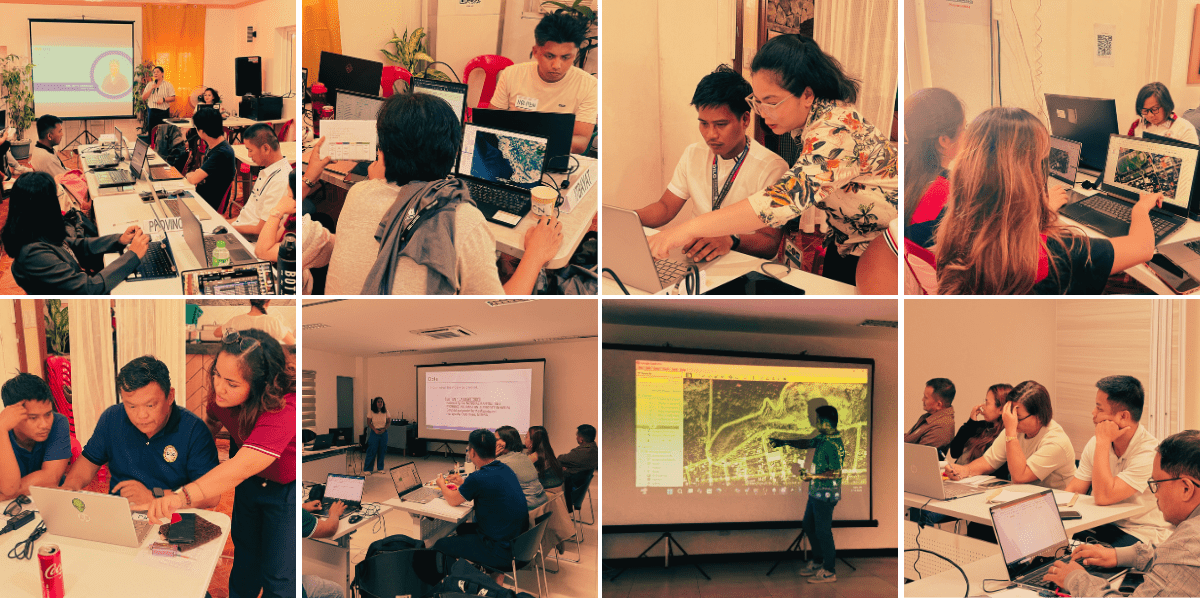
In a province as geographically nuanced and hazard-prone as Batanes, understanding how much participants learn from capacity-building activities is essential. The pre- and post-workshop assessments implemented for the GIS training sessions conducted at the Batanes Resort, Basco last May 19–21, 2025 and at the University of the Philippines Resilience Institute last July 14–18, 2025, were designed to capture how participants’ skills, confidence, and familiarity with basic geospatial concepts shifted over the course of the three-day sessions (Figure 1). By comparing their responses before and after the training, the assessment provides a straightforward picture of what worked, what changed, and how the “learning by doing” approach implemented by the “Bridging Academic Researchers and Vulnerable Island Communities in the Philippines: Enhancing the Climate and Disaster Risk Management Capacities of Municipalities in Batanes, (APN-Batanes)” project helped LGU staff better understand and apply GIS tools in their local context.
Before the workshops began, participants were asked to complete a pre-workshop assessment to gauge their starting point. The evaluation asked them to rate their knowledge, skills, and confidence across key GIS tasks, from understanding basic concepts to performing operations in QGIS, Google Earth Pro, and GPS data handling.
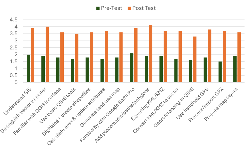
The pre-test results show that many participants entered the training with limited familiarity across most GIS competencies. Self-ratings commonly fell in the 1 to 3 range, reflecting very basic or introductory understanding. Several were unsure about the differences between vector and raster data, how to navigate the QGIS interface, or how to carry out tasks such as digitizing features, converting file formats, or preparing map layouts. Tools outside QGIS, like Google Earth Pro and handheld GPS units, were similarly new to many. This step showed that the Local Government Units (LGU) of Batanes had relatively little prior experience with formal GIS tools, underlining how the training could help them better understand the spatial aspects of their communities, complementing their already established culture of resilience.
Having established this baseline, the post-workshop assessment conducted at the end of the workshop activities provided a clear view of how participants’ knowledge and confidence evolved over the course of the training. By revisiting the same set of tasks and skills, the evaluation highlighted which concepts and tools resonated most, where participants gained confidence, and how hands-on practice helped turn initial uncertainty into practical ability.
The post-test results showed a clear and consistent shift. Across nearly all indicators, participants rated themselves between 3 and 5, signaling improved understanding and growing confidence in using GIS tools. Participants reported stronger grasp of what GIS can be used for, greater ease in distinguishing data types, and improved navigation of the QGIS interface. Tasks that initially appeared challenging, such as georeferencing, digitizing, processing GPS data, exporting and converting files, and organizing map layouts, became more manageable after the hands-on activities. These improvements suggest that the experiential approach helped translate concepts into practical skills that participants could perform on their own.
The column chart below (Figure 2) presents a comparative analysis of the two assessments, showing a clear and consistent increase in participants’ self-assessed knowledge and skills across all GIS-related topics following the training.
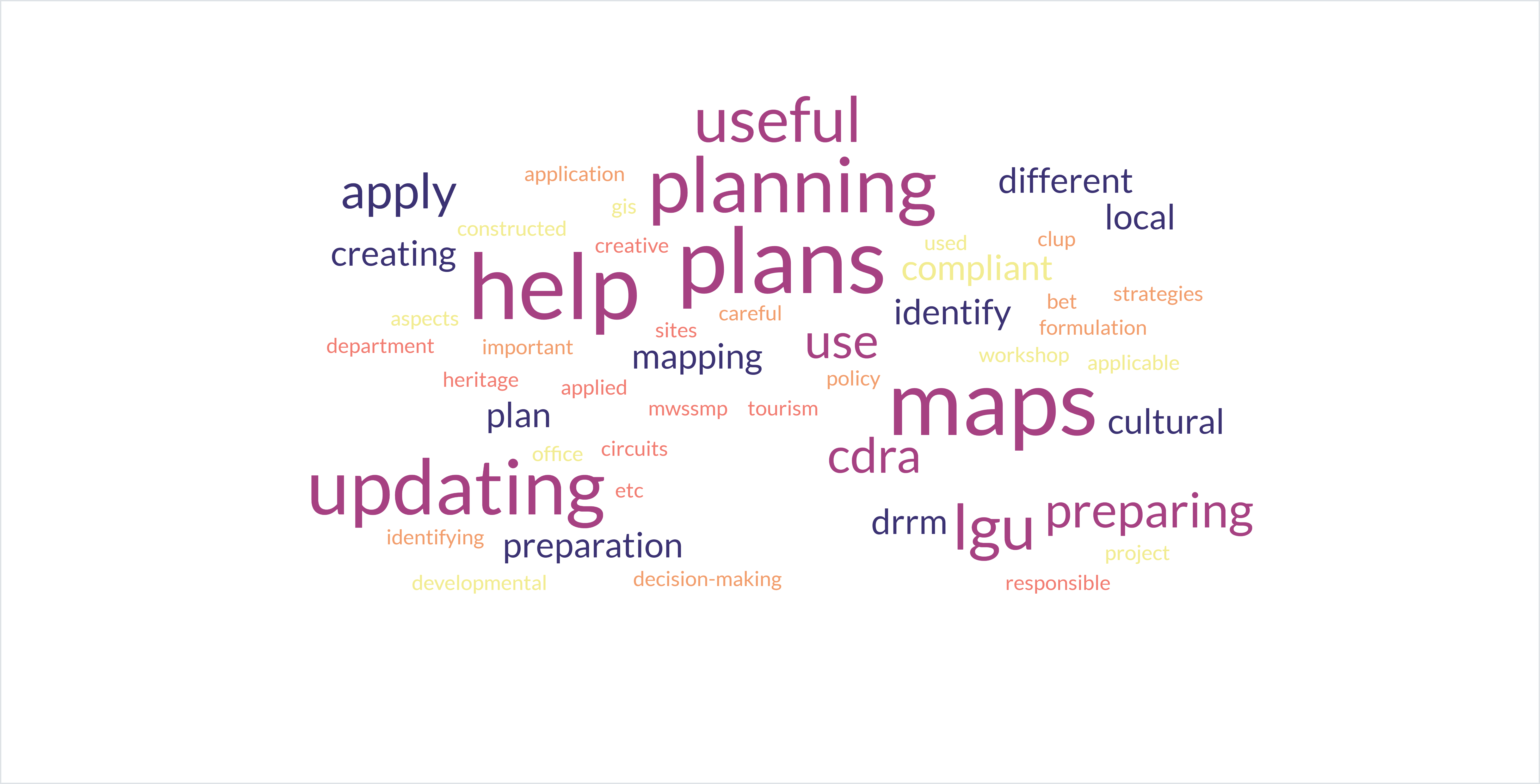
Participants also reflected on where these newly gained skills would be most useful. Many noted that GIS would support the preparation and updating of local plans such as the CLUP, CDRA, and DRRM plans, as well as cultural mapping, tax mapping, hazard mapping, and plotting infrastructure projects (Figure 3). Others shared that it would enhance routine office tasks, particularly those involving location accuracy, map preparation, or monitoring of zoning clearances. Even participants who may not use GIS daily recognized its value for future planning, reporting, and coordination within their LGUs.
Suggestions for improving the workshop further reinforce participants’ desire to continue building their skills. Many requested more time for exercises, access to additional tools such as GPS units, or expanded guidance on specific topics like map layouting. Some expressed interest in more advanced content, including 3D mapping, creating DEMs, hazard modeling, crop mapping, or improving map design. These comments reflect a strong willingness to learn more beyond the introductory sessions and a recognition of the growing role GIS can play in LGU functions.
Taken together, the assessment results show meaningful progress in the GIS capacities of Batanes LGU staff. The shift from limited familiarity to growing confidence demonstrates the value of hands-on, context-specific learning. Beyond just technical skills, the training also helped bridge scientific and mapping tools with the Ivatan people’s deep knowledge of their land, hazards, and resilient ways of living. As Batanes continues to navigate the challenges of its unique geography and exposure to natural hazards, strengthening local capacity in GIS while honoring traditional knowledge remains a crucial step toward more informed plans, programs, and decisions.