By: Kristian Audri Gabriel
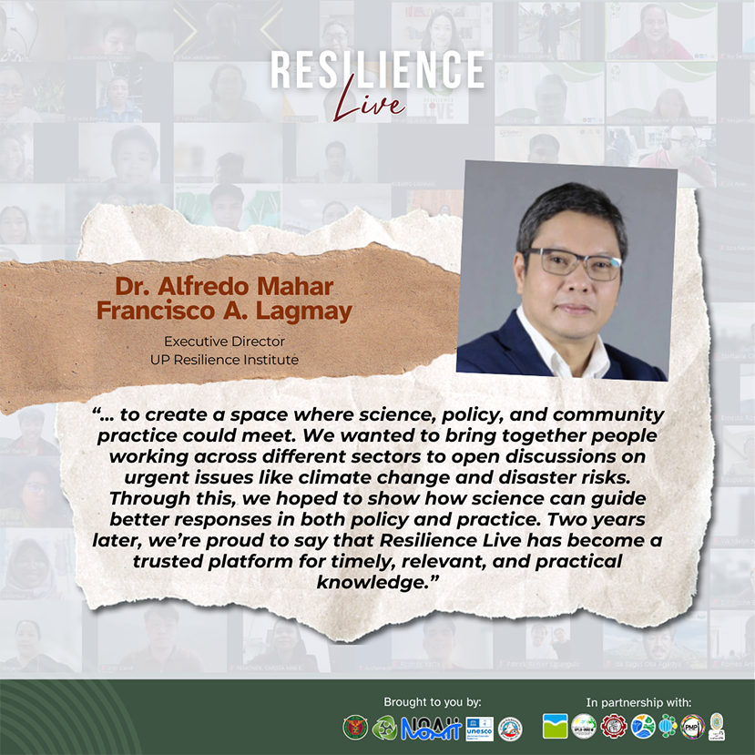
“… To create a space where science, policy, and community practice could meet. We wanted to bring together people working across different sectors to open discussions on urgent issues like climate change and disaster risks. Through this, we hoped to show how science can guide better responses in both policy and practice. Two years later, we’re proud to say that Resilience Live has become a trusted platform for timely, relevant, and practical knowledge.” – Dr. Alfredo Mahar Francisco A. Lagmay, UP RI Executive Director
Over the past year, Resilience Live expanded the conversation on resilience through diverse topics, from spatial thinking, AI and emerging technologies, and Geopark planning to urban mobility, community resilience, and the vital role of LGBTQ+ communities, ensuring each discussion was inclusive, evidence-based, and grounded in real-world experience.
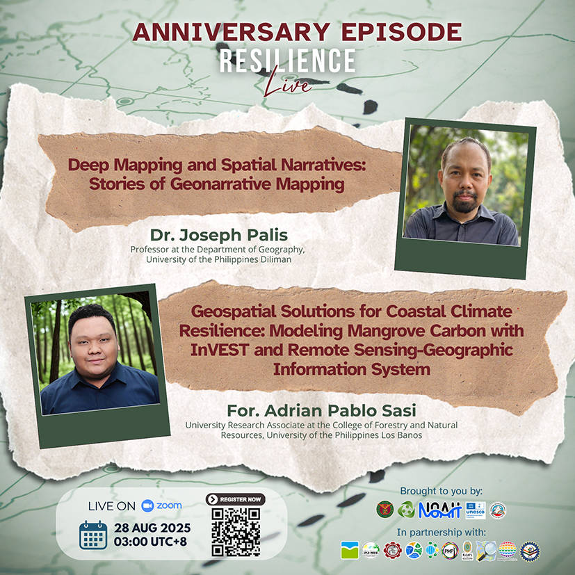
Episode 19, held last August 28, 2025, marked the second anniversary of Resilience Live. Following the same setup as the first anniversary episode, it featured two distinguished speakers whose presentations highlighted the many ways mapping and geospatial science intersected with community resilience. Together, their talks bridged the humanities and natural sciences, showing how maps and ecosystems alike could be read as stories of place, power, and identity.
Deep Mapping, Living Stories
For the 2nd anniversary, Dr. Joseph Palis, a professor of Geography at UP Diliman, explored how mapping and storytelling intersected to create geonarratives and deep maps.
His presentation began by looking at the traditional view of maps as a representation of the Earth in two-dimensional form, like flat drawings of the surface or simple images of what’s around us. According to him, however, maps are not truly neutral. They have historically been used as a language of power, shaping knowledge, controlling spaces, and promoting certain stories while leaving others out, but at the same time, narratives can be reclaimed through countermapping and geonarratives, which highlight the lived experiences, memories, and voices of local communities. These approaches allow mapmakers to emphasize what matters most to them, such as local resources, cultural sites, or everyday experiences, transforming maps into tools of storytelling and resistance. Dr. Palis emphasized, “A place is a story, and stories are geography.” This way, maps move beyond being mere scientific tools and become deeply human practices, giving voice to communities and bringing overlooked stories to light.
Several case studies illustrated how communities use mapping not only to chart landscapes but also to narrate experiences:
– The Lumad of Mindanao mapped their communities under threat, portraying soldiers as busaw, a monster from local folklore, revealing how mapping can embody resistance against militarization.
– Elderly residents in Quezon City used mapping to share fragmented notions of “home,” highlighting displacement, aging, and memory.
– Flood-affected families in Bulacan drew map-stories during quarantine, where storytelling transformed static maps into vivid accounts of survival and resilience.
These examples showed how maps can serve as cultural texts, capturing trauma, resilience, and everyday life.
His presentation also explored personal cartographies and fictional cities as creative mapping practices. Here, mapping moves beyond the physical, blending imagination, desires, fears, and uncertainties. These maps allow people to reimagine spaces, project possibilities, and interrogate realities that may otherwise remain invisible.
Dr. Palis concluded with a reminder that maps are never final—they are “stories-so-far,” always in progress, shaped by encounters with people, places, and institutions. Deep mapping and geonarratives recognize different realities, offering space for alternative voices, community memory, and lived truths.
Valuing Mangroves for Resilience
Complementing the first talk, Forester Adrian Sasi, a scientist from the Interdisciplinary Center for Integrated Natural Resources and Environment Management, University of the Philippines Los Baños, demonstrated how geospatial technologies like InVEST can be used to measure the value of mangroves and support stronger climate adaptation strategies.
For. Sasi emphasized that mangroves are vital to both people and the planet. They act as natural shields against floods and storm surges, provide food and resources, and serve as powerful blue carbon sinks that capture and store carbon in soils and biomass. Using Google Earth Engine with Sentinel-2A imagery and Random Forest classification, his team produced accurate maps of mangrove extent. These maps were analyzed using the InVEST Coastal Blue Carbon model to quantify carbon stocks and translate them into measurable economic value.
A case study in Occidental Mindoro revealed a net gain of 193.80 hectares of mangroves (15.17%) between 2015 and 2023, much of it due to natural recovery. By 2025, these ecosystems were valued at up to ₱2.5 trillion (USD 40.7 billion) for mangroves and ₱551 billion (USD 8.8 billion) for seagrass, underscoring not only their immense ecological role but also their significant contribution to the economy and climate resilience.
Celebrating Two Years of Resilience
As Resilience Live concluded its 2nd year, the webinar team reflected on the breadth of conversations that have shaped our journey, from scientific innovations and cultural narratives to policy directions and community action. These diverse discussions underscored the team’s commitment to fostering inclusive, evidence-based, and practical dialogues that strengthen resilience across contexts.
Resilience Live 2nd Anniversary Episode may be viewed here: https://www.youtube.com/watch?v=hHxta5CVz1k&list=PLUPlFr5hU6jfcVBD9AiOghSwlHi217ypc&index=22
While this marks the last episode for now, Resilience Live is only pausing to reflect and prepare for the next chapter. We look forward to returning with new conversations, fresh insights, and meaningful exchanges that continue to explore resilience in its many forms, building on the lessons of the past two years and charting pathways for the future.