


Banahaw
Mount Banahaw, also known as Banahao, is located in the province of Quezon by the eastern border of the province of Laguna in a protected area known as Mounts Banahaw-San Cristobal Protected Landscape. It rises 2,150 meters above sea level with a basal width of 17 kilometers, basal area of 97.4 square kilometers, and a total volume of 75 cubic kilometers. Banahaw has two volcanoes on its shoulders, the San Cristobal Volcano to the west and Banahaw de Lucban to the northeast. Its summit is a breached crater that is 2 kilometers wide and 600 meters deep from the summit with a notch that opens towards the southwest. Banahaw had a lake but was drained when the crater was breached in 1739. The failure of the southwest crater rim produced widespread lahars that overwhelmed communities south of the volcano. According to the Smithsonian global volcano database, Banahaw erupted in 1730, 1743, 1843, and 1909. However, all these events are uncertain and needs confirmation.
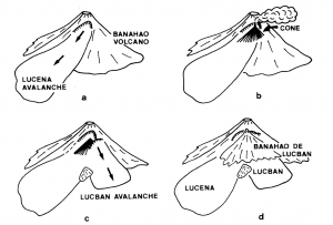
In the northeast flanks of the Banahaw is an 8 km-wide amphitheater scar that is linked to massive landslide events called as debris avalanches. The landslide scar is evident from an elevation of 1,700 meters to 650-meter, and was formed from two discrete edifice collapse events. The two debris avalanche events traveled 26 kilometers to the southeast and 13 kilometers to the northeast, respectively, depositing a total volume of 5 cubic kilometers of debris in Lucban and Lucena. The two overlapping debris avalanche deposits are older than Mt. Banahaw de Lucban. a younger satellite volcanic cone, which juts out of the eastern slopes of Banahaw. The degree of preservation and the absence of a developed soil profile on top of both the debris avalanche deposits suggest a young Holocene age, predating the formation of Banahao de Lucban.
Known as a bundok dambana or holy mountain, Banahaw Volcano is popular amongst locals, pilgrims and mountain climbers as a place to visit. Locals have given the mountain the alternative name of “Vulcan de Aqua” for its abundance of water bodies like natural springs, waterfalls and running streams. Even Cristobal Volcano, the satellite cone on the western flank of Banahaw is popular to thrillseeking mountaineers. Mountain climbers have called Cristobal Volcano as the “horror mountain” due to the negative energy they feel when trekking the area. One of the popular myths surrounding Mt. San Cristobal is the presence of a creature called “Tumao”, which is similar to the Bigfoot in western legends.
Mysticism and folklore surround the supposed origin of Banahaw’s title as a holy mountain. One of the more popular legends starts with a mystic named Agripino Lontok, an “insurrecto” or rebel from Taal, Batangas. He came to the mountain in 1886 to escape capture by the Guardia Civil. There, he acquired powers but at the cost of going blind if he tried to leave Mt. Banahaw. Thus, he became its first caretaker and its first vessel or medium. Until he died in 1930, Banahaw showed Agripino its secrets through spirits or a voice known as “Santong Boses” in an old vernacular, Bornay. Various followers of Agripino settled in different parts and regions surrounding the mountain, forming religious sects and cults of their own.
Fernando Amorsolo, who is the First National Artist of the Philippines, has a series of paintings on Philippine Mountains, many of which are volcanoes. He has captured on several of his artworks the beauty of Banahaw in oil on canvas. The Grand Old Man of Philippine art had a profound appreciation for illustrating the serene lifestyle in the province. Given that the Philippines remained predominantly agrarian and rural until recent times, his artwork vividly captured the placid life of individuals residing in the small barangays and farms throughout the country. Ironically, volcanoes that he has painted in the background, including Banahaw, Cristobal, Banahao de Lucban and Mayon are active volcanoes, which are tumultuous when they become restive.
Other Names: Banahao
Latitude and Longitude: 14.05880 121.48820
Region:Region 4A – CALABARZON
Tectonic Setting: Subduction zone/Continental crust (> 25 km)
Volcanic Arc/Belt: Luzon Volcanic Arc
Volcanic Region/Field: Macolod VF
Volcano Type: Large Cones, Complex Volcano
Last Known Eruption: 1909
Morphometry Type: Breached edifice
Highest Peak (masl): 2150
Coordinates of Highest Peak: 14.06743 121.49211
Prominence (m): 1750
Basal Area (km2): 97.4
Basal Width (km): 17
Volume (km3): 75
How to cite this page:
UPRI (2025). Banahaw: Volcanoes of the Philippines (NOAH Open File Reports). Distributed by the University of the Philippines Resilience Institute, compiled by Ada Beatrice F. Reyes. ISSN 2362 7409.
References:
Austria, R. S.P., Armada, L. T., Parcutela, N. E., Dimalanta, C. B., Payot, B. D., Valera, G. T. V., Reyes, E. M. L., & Yumul, G. P. (2023, September 5). The Macolod Corridor (Philippines)–A passive rift compensated by ponded magmas? ScienceDirect. https://doi.org/10.1016/j.tecto.2023.229965
Geronimo-Catane, S. (1994, June 24). Mode of Emplacement of Two Debris-avalanche Deposits at Banahao Volcano, Southern Luzon, Philippines. Bull. Volcanol. Soc. J apan, Vol. 39 (1994)(No. 3), 113-127. https://www.jstage.jst.go.jp/article/kazan/39/3/39_KJ00003418747/_pdf
Mt Banahaw San Cristobal Mgt Plan Crowdsourcing. (2012, November 09). Facebook. https://www.facebook.com/people/Mt-Banahaw-San-Cristobal-Mgt-Plan-Crowdsourcing/100064971693616/
Newhall, C. (n.d.). Global Volcanism Program | Banahaw. Global Volcanism Program. Retrieved July 29, 2024, from https://volcano.si.edu/volcano.cfm?vn=273050
Paguican, E. M., Grosse, P., Fabbro, G. N., & Kervyn, M. (2021, October). Morphometric classification and spatial distribution of Philippine volcanoes. ScienceDirect. https://doi.org/10.1016/j.jvolgeores.2021.107251
PHIVOLCS. (n.d.). PHIVOLCS-LAVA. https://wovodat.phivolcs.dost.gov.ph/volcano/erupt-history?volcan=578&sdate=&edate=&btn-search=
Siebert, L., Simkin, T., & Kimberly, P. (2010). Volcanoes of the World: Third Edition. University of California Press.
Zaballero, R. D., Belmonte, S. K., Binwag, M. L., & Herras, J. (2019). LAHAR RISK MAPPING OF BANAHAW VOLCANO, SOUTHERN LUZON USING LAHARZ. GEOLOGICAL SOCIETY OF THE PHILIPPINES. https://www.geolsocphil.org/geocon2019/papers/Zaballero.pdf
Municipality of Sariaya, Quezon (2020). Mt. Banahaw. Accessed 12 February 2025. URL https://www.sariaya.gov.ph/2020/09/29/mt-banahaw/
Gorospe, V. (1992). Mount Banahaw: The Power Mountain From Ritualism to Spirituality. Philippine Studies, Second Quarter 1992, Vol. 40, No. 2. URL https://www.jstor.org/stable/pdf/42633309.pdf
Geocities (2025). Mt. Cristobal. Accessed 12 February 2025. URL https://www.geocities.ws/pasakat/Cristobal.htm
Global Volcanism Project (2013). Banahaw. Accessed 12 February 2025. URL https://volcano.si.edu/volcano.cfm?vn=273050