


Biliran
Biliran is a composite volcano situated on Biliran Island, within the province of Biliran in the Eastern Visayas region of the 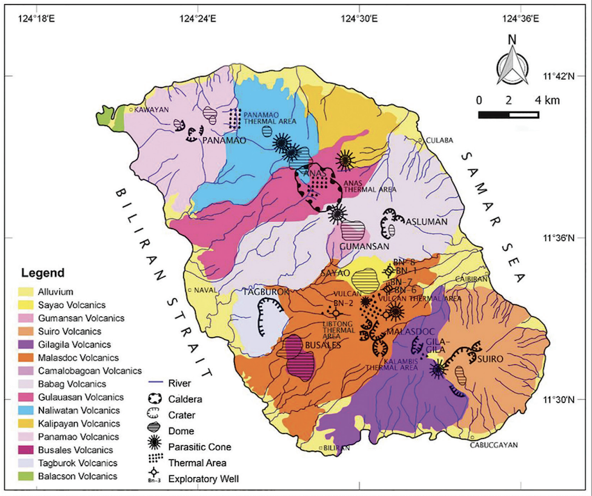 Philippines. This landmass, measuring 20 by 35 kilometers, is surrounded by the waters of Biliran Strait, Carigara Bay, and the Visayas Sea, and has been formed entirely by volcanic eruptions. Andesitic lava domes and fumarolic fields are characteristic of volcanoes in the island. The Province of Biliran consists of one active, one potentially active, and fourteen inactive volcanoes. With the exception of the potentially active Maripipi Volcano, all of these geological formations are situated on the main island of Biliran. Tagged as a potentially active volcano, Maripipi, which is also part of the Province of Biliran, has formed its own island as a result of its volcanic eruptions. All volcanoes in Biliran Province are part of the East Philippine Arc, which are related to the subduction of the Philippine Sea Plate along the Philippine Trench.
The latest documented eruption of Biliran Island occurred in 1939; however, the most significant event, as per local narratives, took place in the 1600s. Accounts indicate that Mount Panamao was the reason for the island’s renaming to Biliran, a measure taken by the inhabitants to appease malevolent spirits after its eruption in 1669. Interestingly, at the northernmost point of Biliran lies a mountain called as Mount Panamao, officially identified as an inactive volcano and distinct from the larger, active Biliran Volcano situated further southeast. Mount Panamao may have been the volcano that was described as eruptive by Fr. Francisco Alcina, who wrote in 1668 that he had often seen the mountains on the island of Panamao “throwing out fire, especially on very dark and stormy nights.” The following year, considered a milestone year in Tacloban history was when a “rain of ashes” was experienced in villages of Tacloban, Leyte. The ash fall is believed to have originated from Mount Panamao, because of the accounts of Fr. Alcina. These accounts raise the question of whether the island’s name change from Panamao to Biliran was influenced by the volcanic activity of Mount Panamao at the island’s northern tip or by the active Biliran Volcano, which stands as the tallest and most prominent feature of Biliran Island.
Local stories also describe an eruption that occurred in 1800 in central Biliran, prompting a petition to relocate the poblacion of Caibiran. The eruption took place near the Tinago village and was described as “fire and rocks spewing out of the crater” that lasted for two hours. The specific volcano responsible for this event remains unidentified, though it has been suggested that it might have been one of the vents located in the Libtong Thermal Areas. Although the last officially recorded eruption in Biliran Island was in 1939, which possibly generated a debris avalanche, the historical accounts of Fr. Alcina and the descriptions of an eruptive event in 1800, suggest at least two more historical eruptions that may have involved Mount Panamao in northern Biliran and an unspecified volcano in Central Biliran. This is in addition to the Pleistocene eruptive events that have taken place in the area as determined by K-Ar dating of volcanic samples from northern Biliran Island.
Other stories about Panamao are found in various myths and legends. In the the towns of Almeria and Kawayan, which are both located at the foot of Mount Panamao north of Biliran Island, people believe that Mount Panamao is inhabited by a fairy or “Diwata“. The enchanting lady recognized by the inhabitants of the towns of Almeria and Kawayan is a lovely maiden referred to as Maria Benita. The name Benita, derived from Spanish, signifies “benighted” or “overcome by darkness.” According to Almeria’s legend, Maria Benita fell in love with a local farmer who also loved her deeply. But their love did not last long. While the lovers were playing one moonlit night, a hunter killed the farmer. Until today, the people of Almeria believe that Maria Benita still sings for her lost love. To the people of Kawayan, however, the lover of Maria Benita was a local game-hunter and not a farmer. They believe that she sometimes appears in human form to the townspeople when she descends from the mountains to get wild pigs for her lover. According to historians, the conflicting versions of the legend of Maria Benita is a reflection of the feud between the towns of Almeria and Kawayan.
Other Names: Anas Volcanic Complex and Suiro Volcanic Complex
Latitude and Longitude:
Anas: (Latitude) 11.63268, (Longitude) 124.47162
Lauaan: (Latitude) 11.5216643, (Longitude) 124.5336119
Panamao: (Latitude) 11.668242, (Longitude) 124.394298
Vulcan: (Latitude) 11.533802, (Longitude) 124.50502
Region: Region 8
Tectonic Setting: Subduction (Philippine Trench)
Volcanic Arc/Belt: East Philippine Volcanic Arc
Volcanic Region/Field: East Visayas Volcanic Region
Volcano Type:
Biliran: Compound Volcano
Anas: Crater
Lauaan: ND
Panamao: Stratovolcano
Vulcan: Cone
Last Known Eruption:
1939 [Unspecified vent]
Panamao: 1669
Morphometry Type:
Panamao: Small steep cone
Vulcan: Subcone
Elevation (masl):
Anas Crater: 615
Lauaan: 1,170
Vulcan: 989
Prominence (m):
Lauaan: 130
Panamao: 953
Vulcan: 951
Basal Area (km2):
Panamao: 44.2
Vulcan: 39.1
Basal Width (km):
Panamao: 7.5
Vulcan: 7.05
Volume (km3):
Panamao: 9.0
Vulcan: 7.74
How to cite this page:
UPRI (2025). Biliran: Volcanoes of the Philippines (NOAH Open File Reports). Distributed by the University of the Philippines Resilience Institute, compiled by Julian Marie Bernice M. Grageda. ISSN 2362 7409.
References:
Apuada, N. A., Sigurjonsson, G. F., & Oanes, A. F. (2010). Evaluation of the Hydrothermal System of Biliran Island, Philippines. Proceedings World Geothermal Congress 2010, Bali, Indonesia.
Bayaga, C. F. (2024, November 2). Cebuano historian puts spotlight on ‘enchanted cities,’ deities in Visayas. Rappler. https://www.rappler.com/philippines/visayas/cebuano-historian-enchanted-cities-deities-forum-october-2024/
Borrinaga, R. (2004, February 21). The legend of Punta de Bulalacao. The Philippine Daily Inquirer.
Borrinaga, R.O. (2007, December 1). Volcano scare in Biliran. Philippine Daily Inquirer. https://books.google.com.ph/books?id=klM1AAAAIBAJ&dq=1939+philippines+eruption&source=gbs_navlinks_s
Global Volcanism Program, 2024. Biliran (272080) in [Database] Volcanoes of the World (v. 5.2.0; 6 Jun 2024). Distributed by Smithsonian Institution, compiled by Venzke, E. https://doi.org/10.5479/si.GVP.VOTW5-2024.5.2
Granali, B. (1991, May 14). Legend of Biliran – Isla de Panamao (Isle of Mystery and Magic). Women’s Journal.
Mendoza, J.P. A., Balangue-Tarriela, M.I.R., & Reed, M.H. (2019). Modeling Adiabatic Boiling in the Biliran Geothermal Wells Using CHIM-XPT (2016). Philippine Journal of Science, 148(4),
MGB. (2010). Geology of the Philippines (2nd ed.).
Niez, R. A. (2024). Genre and motif variations in Biliran folk narratives: Insights for literary and cultural studies. Edelweiss Applied Science and Technology, 8(5), 2377-2393.
OpenStreetMap contributors. (2015) Planet dump [Data file from 2024 June 23]. Retrieved from https://planet.openstreetmap.org.
Pagado, E.S., Camit G.R.A., Rosell J.B., Apuada N.A. 1995. The Geology and Geothermal Systems of Biliran Island. Journal of the Geological Society of the Philippines 5(1): 21–36.
Paguican, E. M., Grosse, P., Fabbro, G. N., & Kervyn, M. (2021). Morphometric classification and spatial distribution of Philippine volcanoes. Journal of Volcanology and Geothermal Research, 418. https://doi.org/10.1016/j.jvolgeores.2021.107251
PHIVOLCS. (n.d.). Inactive Volcano List (Ongoing Audit). PHIVOLCS-Local Active Volcanoes Archive (LAVA). https://wovodat.phivolcs.dost.gov.ph/
PHIVOLCS. (n.d.). Volcanoes of the Philippines. PHIVOLCS. https://www.phivolcs.dost.gov.ph/index.php/volcano-hazard/volcanoes-of-the-philippines
PHIVOLCS. (2000). Photogeologic Map of Biliran Island [Map]. https://www.biliranisland.com/blogs/wp-content/uploads/2018/01/Photogeologic-map-biliran.jpg
PHIVOLCS. (2022). Volcanic Hazard Map of Biliran Volcano (Anas & Suiro Volcanic Complex) [Map]. PHIVOLCS.
PHIVOLCS. Lava Flow Hazard Map of Biliran Volcano (Anas & Suiro Volcanic Complex). [Map] Version 1. 1:40,000. Quezon City, Philippines: DOST-PHIVOLCS, February 2023.
PHIVOLCS. Volcanic Hazard Map of Biliran VOlcano (Anas & Suiro Volcanic Complex). [Map] Version 1. 1:40,000. Quezon City, Philippines: DOST-PHIVOLCS, September 2023.
PHIVOLCS. (2024). Volcanoes of the Philippines. PHIVOLCS.