


Cagua
Cagua Volcano is located at the northeastern tip of the Cagayan Region in Luzon. It is the only known active volcano in the Sierra Madre Mountain range. Classified as a stratovolcano, Cagua Volcano is primarily composed of basaltic-andesite and basaltic lava flows. The volcano has a peak elevation of 1,133 meters, with a basal area covering 84.9 square kilometers and an estimated volume of 31 cubic kilometers. The summit crater spans 1.5 kilometers in diameter and is marked by steep, 60-meter-high walls. It is called “Bantay ti Apuy”, which means “Mountain of Fire” due to the sulfuric fumaroles that emit steam around it peak.
Two significant volcanic events have been recorded for Cagua Volcano. The first was a phreatic eruption in 1860, which may have been accompanied by pyroclastic flows. The second occurred in 1907 when strong solfataric activity was observed. However, there has been no estimate of the size of the eruptions for these two events. Although its last recorded activity occurred over 100 years ago, much of the area surrounding Mt. Cagua is still classified as within the “lava flow hazard zone” as it is still classified by the Philippine Institute of Volcanology and Seismology (Phivolcs) as an active volcano. There are only 99 people living within a 5 kilometers radius and 1,137 residents within 10-kilometers distance from the volcano’s summit (GVP, 2024).
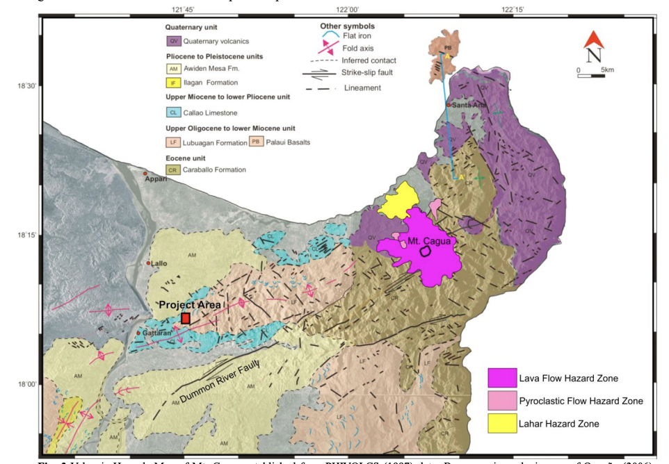
Cagua’s geographical position distinguishes it from other active volcanoes in the Philippines, as it is the sole active volcano in Luzon that is not situated near another recognized volcano. In addition to the lack of nearby active, potentially active, or dormant volcanoes, it is also located one hundred kilometers away from the Philippine Fault, which is one of the most destructive faults of the world. The distinctive characteristics of the region where Cagua Volcano is located, render it a viable candidate for a low- and intermediate-level radioactive waste (LILW) repository. Aurelio et al. (2013) recognized that mass movements, seismic activities, and volcanic hazards could impact the proposed LILW site; however, these risks can be mitigated through the application of suitable design standards that will ensure safety during the entire operational period of the facility.
Other Names: Kawa, Caua, Gagua
Latitude and Longitude: 18.22051 122.11095
Region: Region 2
Tectonic Setting: Subduction (East Luzon Trench)
Volcanic Arc/Belt: Taiwan-Luzon Volcanic Arc
Volcanic Region/Field: –
Volcano Type: Stratovolcano
Last Known Eruption: 1907
Morphometry Type: Cone
Highest Peak (masl): 1160
Coordinates of Highest Peak: 18.21580 122.12047
Prominence (m): –
Basal Area (km2): 84.9
Basal Width (km): 10.4
Volume (km3): 31
How to cite this page:
UPRI (2025). Cagua: Volcanoes of the Philippines (NOAH Open File Reports). Distributed by the University of the Philippines Resilience Institute, compiled by Cristan M. Malaiba. ISSN 2362 7409.
References:
Aurelio, M. A., & Peña, R. E. (2010). Geology of the Philippines. Mines and Geosciences Bureau, Manila.
Aurelio, M., Taguibao, K. J., Vargas, E., Palattao, M. V., Reyes, R., Nohay, C., Luna, R. A., Singayan, A., (2013) – Geological Criteria for Site Selection of an LILW Radioactive Waste Repository in the Philippines.
Defant, M. J., Maury, R. C., Joron, J. L., Feigenson, M. D., Leterrier, J., Bellon, H., Jacques, D., Richard, M., (1990) – The geochemistry and tectonic setting of the northern section of the Luzon arc (the Philippines and Taiwan)
Paguican, E. M. (2012). The structure, morphology, and surface texture of debris avalanche deposits: Field and remote sensing mapping and analogue modelling (Doctoral dissertation, Université Blaise Pascal – Clermont-Ferrand II).
Global Volcanism Program, 2024. Cagua (273090) in [Database] Volcanoes of the World (v. 5.2.1; 3 Jul 2024). Distributed by Smithsonian Institution, compiled by Venzke, E. https://doi.org/10.5479/si.GVP.VOTW5-2024.5.2
McDermott, F., Defant, M. J., Hawkesworth, C. J., Maury, R. C., Joron, J. J. (1993) – Isotope and trace element evidence for three component mixing in the genesis of the North Luzon arc lavas (Philippines)
PHIVOLCS-LAVA Eruption History. https://wovodat.phivolcs.dost.gov.ph/volcano/erupt-history
Yang, T. F., Tien, J. L., Chen, C. H., Lee, T., Punongbayan, R. S. (1995) – Fission-track dating of volcanics in the northern part of the Taiwan-Luzon Arc: eruption ages and evidence for crustal contamination