


Iraya
Mount Iraya, also referred to as Irada, is a stratovolcano situated on Batan Island in Batanes, Philippines. It stands as the northernmost active volcano in the Philippines and is one of three volcanoes located on Batan Island within the Batanes Volcanic Region. The series of volcanoes in the Batanes Islands is part of the Luzon Volcanic Arc, which was formed as a result of the subduction of the Manila Trench.
Iraya reaches a peak elevation of 1,009 meters above sea level and has a basal width of approximately 6 kilometers. Towering over the town of Basco, the volcano has recorded three confirmed historical eruptions. The most recent eruption occurred in 1454, based on documented observations according to the Smithsonian Global Volcanism Program. Additionally, two eruptions took place around 250 CE ± 200 years and 470 CE ± 50 years, as determined by radiocarbon dating. Both of these eruptions were characterized by explosive activity, ash emissions, and pyroclastic flows. In 1998, a seismic swarm was detected near Iraya, which prompted the establishment of a temporary monitoring network on Batan Island.
The lava deposits of Mount Iraya are basaltic to andesitic composition. These often include rock fragments that originate from the Earth’s mantle at depths exceeding 30 kilometers. Other deposits that characterize Iraya volcano include pyroclastic fall, pyroclastic flow, and lahar deposits. Based on these deposits, the volcano is evaluated as having the potential for explosive volcanism, posing a threat to the municipality of Basco, the capital of Batanes.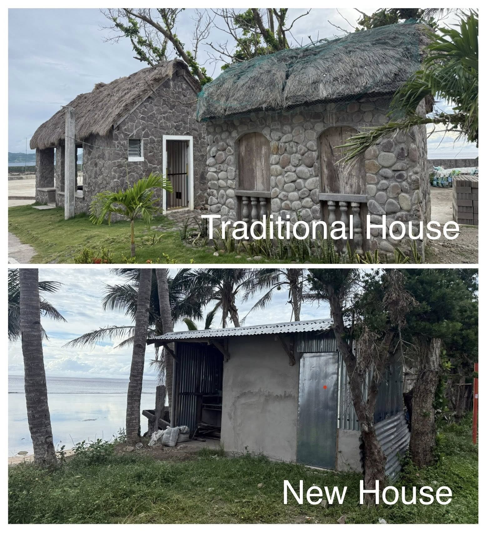
Mount Iraya is intricately woven into the local culture of Batanes and is frequently associated with folktales and legends that have been passed down through oral tradition by the Ivatan people. The mountain is regarded with a mystical and revered status and is connected to numerous beliefs. One commonly shared story depicts Mount Iraya as a maternal figure, a nurturing presence in the lives of the local populace, watching over the Ivatans to ensure their safety. The Ivatan people also hold a belief in an omen that indicates the impending death of an elder when a ring of clouds encircles the peak of Mount Iraya. Another is when the mountain is distinctly visible, the locals advise to make a wish, as it is believed that it will come true.
Mount Iraya stands as both a geological marvel and a cultural symbol of Batanes. With its history of eruptions, distinctive geological characteristics, and profound cultural relevance, the volcano continues to be a significant figure in both scientific and cultural contexts within the Philippines. Due to this rich legacy, the Province of Batanes was designated as a protected area under Republic Act No. 8991. While the intention behind this legislation is commendable, it prevents the use of volcanic rocks and clay from the island in the construction of traditional homes. As a result, residents have noted a considerable rise in the number of houses that have been damaged during extreme weather events since the enactment of the protected area law in 2000.
Other Names: Irada
Latitude and Longitude: 20.46665 122.01161
Region: Region 2
Tectonic Setting: Subduction (Manila Trench)
Volcanic Arc/Belt: Luzon Volcanic Arc (Batanes Volcanic Arc)
Volcanic Region/Field: Batanes Volcanic Region
Volcano Type: Stratovolcano
Last Known Eruption: 1454
Morphometry Type: –
Highest Peak (masl): 1009
Coordinates of Highest Peak: 20.46665 122.01161
Prominence (m): –
Basal Area (km2): –
Basal Width (km): 6
Volume (km3): –
How to cite this page:
UPRI (2025) Iraya: Volcanoes of the Philippines (NOAH Open File Reports). Distributed by the University of the Philippines Resilience Institute, compiled by Charles Kendrick O. Epino. ISSN 2362 7409.
References:
Defant, Marc & JACQUES, DARIO & Maury, René & BOER, JELLE & Joron, J.-L. (1989). Geochemistry and tectonic setting of the
Luzon Arc, Philippines. Geological Society of America Bulletin – GEOL SOC AMER BULL. 101. 663-672.
10.1130/0016-7606(1989)101<0663:GATSOT>2.3.CO;2.
Global Volcanism Program, 2024. Iraya (274060) in [Database] Volcanoes of the World (v. 5.2.1; 3 Jul 2024). Distributed by Smithsonian
Institution, compiled by Venzke, E. https://doi.org/10.5479/si.GVP.VOTW5-2024.5.2
Moriya, I. Evolution and Classification of Volcanic Edifices on the Philippine Islands, Journal of Geography (Chigaku Zasshi), 2014,
Volume 123, Issue 1, Pages 89-122, Released on J-STAGE March 07, 2014, Online ISSN 1884-0884, Print ISSN 0022-135X,
https://doi.org/10.5026/jgeography.123.89, https://www.jstage.jst.go.jp/article/jgeography/123/1/123_123.89/_article/-char/en,
NAMRIA. 2004. Topographic Map of Batanes. https://namria.gov.ph/downloads/topomap50/3341-IBasco.jpg
PHIVOLCS. 2023. Lava flow hazard map of Iraya Volcano.
https://gisweb.phivolcs.dost.gov.ph/gisweb/storage/hazard-maps/region-ii-(cagayan-valley)/batanes/provincial/volcano/lava-flow/lav_
2023_020900000_01.png
PHIVOLCS. 2023. Pyroclastic density current and lahar hazard map of Iraya Volcano.
https://gisweb.phivolcs.dost.gov.ph/gisweb/storage/hazard-maps/region-ii-(cagayan-valley)/batanes/provincial/volcano/lahar/lhr_2023
_020900000_01.png
PHIVOLCS. n.d. Volcanoes of the Philippines.
https://wovodat.phivolcs.dost.gov.ph/volcano/erupt-history?volcan=595&sdate=&edate=&btn-search=
Vidal, C. Dupuy, R. Maury, M. Richard; Mantle metasomatism above subduction zones: Trace-element and radiogenic isotope
characteristics of peridotite xenoliths from Batan Island (Philippines). Geology 1989;; 17 (12): 1115–1118. doi:
https://doi.org/10.1130/0091-7613(1989)017<1115:MMASZT>2.3.CO;2