


Leonard Kniaseff
Listen to how the last name of Leonard is pronounced by clicking on this link ![]() .
.
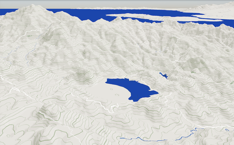 Leonard Kniaseff is an approximately 3 x 3 km caldera located east of Davao Gulf near the Philippine fault in Mindanao. The highest part of the rim stands at 1,090 meters above sea level. It is part of the Amacan Volcanic Complex in the province of Davao de Oro (MGB, 2010), which features a terrain that is of higher relief compared to the Leonard Kniasseff caldera rim. A phase of dacitic magmatic activity began around 290,000 years ago, leading to the development of multiple lava domes near Lake Leonard. This was followed by a phase involving the eruption of the Paloc pyroclastic deposits, which occurred from the late Pleistocene to the Holocene, alongside the development of the caldera where the Leonard Kniaseff Lake is nested.
Three eruptive events have been reported for the Leonard Kniaseff volcano which happened 0080 ± 60 years, 0077 BCE ± 54 years and 4092 BCE ± 122 years ago (GVP, 2024). These dates are age dates of the Paloc pyroclastic deposits which were analyzed using radiocarbon methods (Ramos et al., 2000). Additionally, multiple thermoluminescence dates from the Holocene, some of which are only a few hundred years old, were acquired from lava domes and pyroclastic deposits. However, Ramos et al. (2000) pointed out that these thermoluminescence ages were considerably younger than the corresponding radiocarbon ages, raising questions regarding their reliability.
The volcano was named after Leonard Kniasseff, a mining prospector who became the first general superintendent of the Samar Mining Company (SAMICO) when it commenced its mining activities in the region before the onset of the war. He came across the lake while exploring the area for minerals in the 1930s. Lake Leonard, formerly known as Crocodile Lake, was named by the Mansaka people who recognized the lake as a habitat for the Philippine crocodile (Crocodylus mindorensis). The lake is surrounded by thermal features, including solfataras, fumaroles, and hot springs. The Manat and Amacan-Gopod thermal regions are situated to the north and south of the lake, whereas the southwest perimeter of Leonard Kniassef is characterized by fumaroles and solfataras.
Human activities within the watershed has significantly contributed to heavy siltation of the lake’s shoreline. Road construction, shifting cultivation, logging, and the disposal of mine tailings have also degraded the lake’s aquatic ecosystem. The transformation of the peripheral regions surrounding the caldera lake into settlements for company employees and small-scale miners has been accompanied by neglect of the environment, abuse, and deforestation. Additionally, the indigenous communities have experienced significant social repercussions due to the growth of mining communities (Figueroa, 2020).
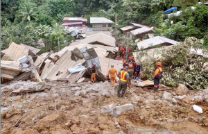 The Masara Gold District, located near Leonard Kniaseff, is recognized for its abundant hydrothermal mineralization of copper and gold. It offers one of the biggest potential deposits out of the six gold districts in the Philippines with known bonanza-grade gold veins (Buena et al., 2019). On 6 February 2024, at 7:30 PM, a rain-induced landslide overwhelmed a small mining community in Barangay Masara in Maco, Davao de Oro about 3 km west of Lake Leonard. The Masara landslide buried numerous structures of the mining community, including the barangay hall, three service buses transporting workers from a nearby mining site, a jeepney, and dozens of houses. According to the Maco Municipal Disaster Risk Reduction and Management Council (MDRRMC) the landslide caused 93 deaths with eight still missing.
Other Names: Leonard, Lake Leonard, Leonard Kniazeff, Crocodile Lake
Latitude and Longitude: 7.39444 126.06385
Region: Region 11 (Davao Region)
Tectonic Setting: Subduction (Philippine Trench)
Volcanic Arc/Belt: East Philippine Volcanic Arc
Volcanic Region/Field: South Mindanao Volcanic Region
Volcano Type: Maar
Last Known Eruption: 80 CE
Morphometry Type: Large Cones
Highest Peak (masl): 1190
Coordinates of Highest Peak: 7.38381 126.06895
Prominence (m): 187
Basal Area (km2): 366.4
Basal Width (km): 17.6
Volume (km3): 270
How to cite this page:
UPRI (2025). Leonard Kniaseff: Volcanoes of the Philippines (NOAH Open File Reports). Distributed by the University of the Philippines Resilience Institute, compiled by Audrei Anne B. Ybañez. ISSN 2362 7409.
References:
Global Volcanism Program, 2024. Leonard Range (271031) in [Database] Volcanoes of the World (v. 5.2.0; 6 Jun 2024). Distributed by Smithsonian Institution, compiled by Venzke, E. https://doi.org/10.5479/si.GVP.VOTW5-2024.5.2
Paguican, E. M., Grosse, P., Fabbro, G. N., & Kervyn, M. (2021). Morphometric classification and spatial distribution of Philippine volcanoes. Journal of Volcanology and Geothermal Research, 418. https://doi.org/10.1016/j.jvolgeores.2021.107251
PHIVOLCS. (nd). Volcanoes of the Philippines. PHIVOLCS. https://www.phivolcs.dost.gov.ph/index.php/volcano-hazard/volcanoes-of-the-philippines
Ramos, S., Zaide-Delfin, M., & Takashima, I. (2000). Thermoluminescence Dating and Mt. Lago and North Davao, Philippines: Implications on Geothermal Models. Proceedings World Geothermal Congress.
Sajona, F. G., Bellon, H., Maury, R. C., Pubellier, M., Cotten, J. & Rangin, C. (1994). Magmatic response to abrupt changes in geodynamic settings: Pliocene-Quaternary calc-alkaline and Nb-enriched lavas from Mindanao (Philippines). Tectonophysics, 237, 47-72.
Sajona, F. G. (2008). Masara District Revisited. Geocon 2008 Reports. https://www.geolsocphil.org/geocon_abstracts/geocon2008_03.htm