By. Ms. Ella Danielle C. Santiaguel, EnP.
Last May and July 2025, representatives from the Provincial Government of Batanes and its six municipalities—Basco, Itbayat, Ivana, Mahatao, Sabtang, and Uyugan—gathered to participate in a series of Geographic Information System (GIS) trainings organized by the University of the Philippines Resilience Institute (UP RI). The activity was conducted as part of the ongoing project Bridging Academic Researchers and Vulnerable Island Communities in the Philippines: Enhancing the Climate and Disaster Risk Management Capacities of Municipalities in Batanes, Philippines, funded by the Asia-Pacific Network for Global Change Research (APN), also referred to as the APN-Batanes Project.
Learning and Doing for Resilience
GIS is a digital tool that allows users to capture, analyze, and visualize geographically referenced data (Environmental Systems Research Institute Inc. (ESRI), n.d.). In the context of resilience building, GIS helps in understanding how people, infrastructure, and natural systems interact within a given landscape. It provides the spatial foundation for conducting climate and disaster risk assessment (CDRA) (Housing and Land use Regulatory Board (HLURB), 2015) which is a process that identifies which areas, sectors, or assets are most exposed and vulnerable to hazards.
This foundational role of GIS is especially important in Batanes—known for its stunning landscapes and resilient communities but increasingly challenged by climate change and natural hazards. Through the APN-Batanes project, UP RI aims to strengthen local capacities by integrating scientific methods with traditional knowledge. The recent GIS training embodied the first two phases of the project’s experiential approach, Learn and Do, where participants first gained essential technical knowledge and then immediately applied it through hands-on exercises.
Mapping the Land: A Participatory Effort
One of the major outputs of the training was the preparation of updated Existing Land Use (ELU) maps of the municipalities (Figure 1). Using spatial data and their local knowledge, the LGU representatives mapped their locality’s existing land uses, including infrastructure, commercial areas, institutional sites, residential zones, agricultural lands, agri-industrial facilities, parks, and open spaces (Figure 2).
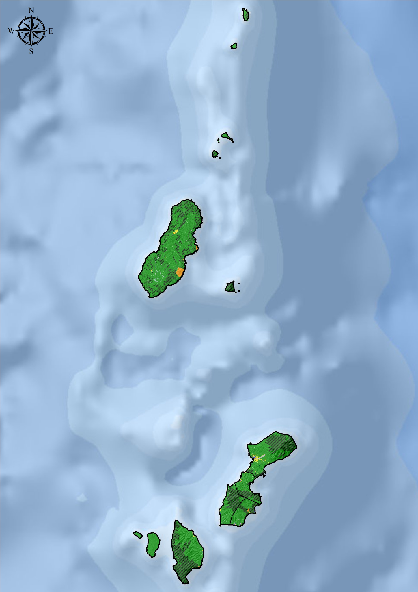 Figure 1. Existing Land Use Map of the Province of Batanes
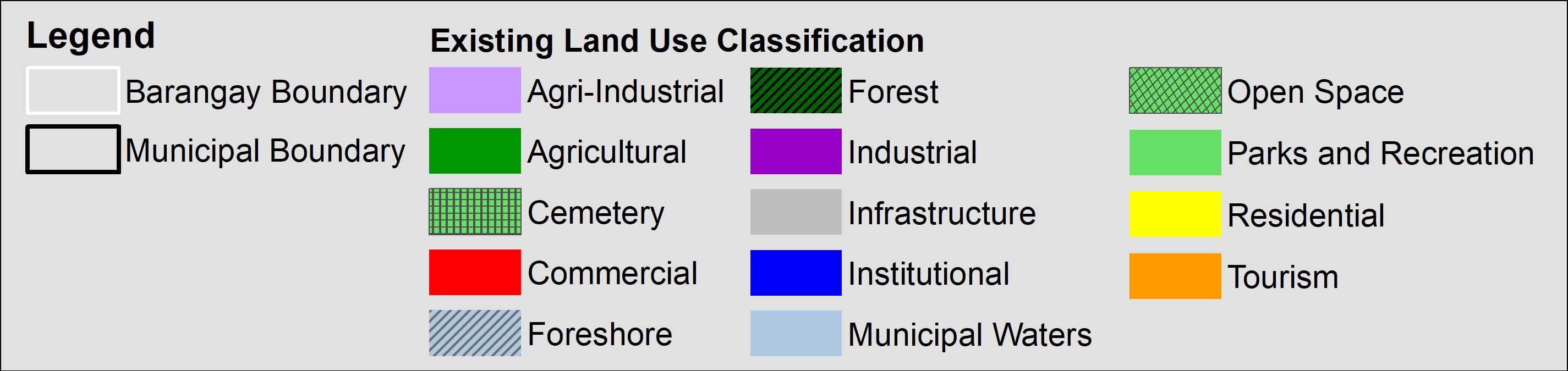 Figure 2. Legend for the Batanes Existing Land Use Maps
These updated ELU maps are essential inputs in examining the exposure and vulnerability of communities and assets and in determining risk levels. Updated ELU maps help define exposure units, or the specific land use categories that represent different assets and functions within a community. Each exposure unit, whether referring to the population, critical point facilities, urban use areas, lifeline utilities, or natural resource-based production areas, faces varying degrees of exposure and vulnerability to hazards. By accurately mapping these, LGU officials can better visualize and identify which areas and sectors are most at risk. This enables them to prioritize interventions, strengthen preparedness, and guide future land use and development decisions that reduce disaster impacts and build resilience.
The mapping process was participatory from start to finish. LGU representatives validated their maps using their local familiarity, while in some municipalities, barangay officials were also involved to ensure that on-the-ground realities were properly reflected. To supplement local data, remote sensing techniques were introduced, allowing participants to view their landscapes through satellite imagery. However, as emphasized during the training, scientific tools such as remote sensing must always be verified with local insights to produce reliable and context-sensitive maps. Cross-referencing was another key step. The ELU maps were compared with the latest lists of commercial establishments provided by the LGUs, further refining the accuracy and completeness of the datasets.
From Data to Action
Through the GIS training, participants not only learned new technical skills but also produced tangible outputs in the form of their municipalities’ ELU maps. These outputs signify a key transition from learning to application, reflecting the project’s goal of integrating capacity development into actual planning processes. The completed maps will serve as primary references for the upcoming project phase, ensuring that risk assessments and local development plans in Batanes are data-driven, inclusive, and responsive to the province’s unique landscape and community context.
Below are the outputs from the land use mapping activity, showcasing the existing land use maps of each municipality in Batanes:
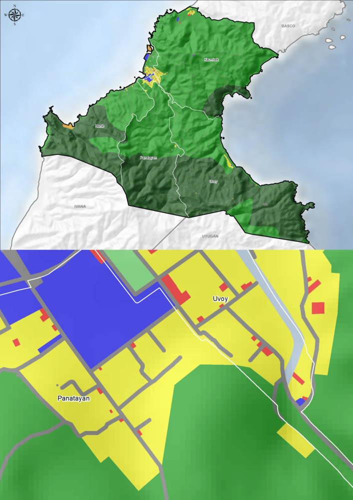
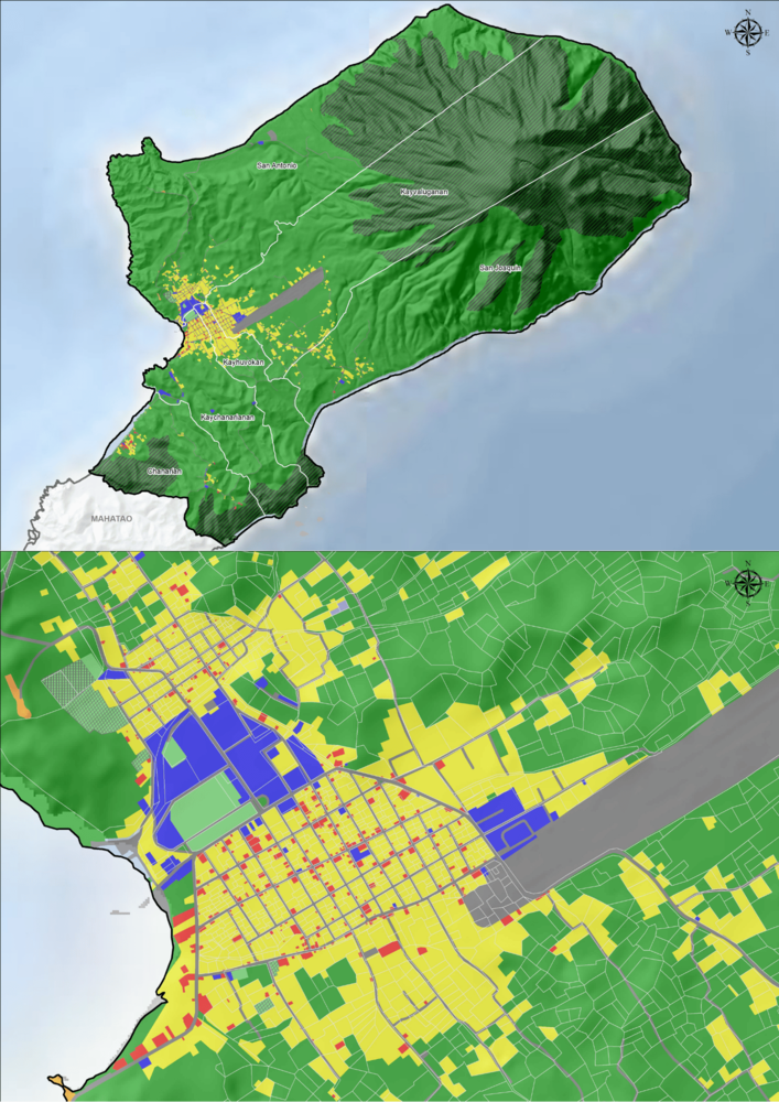 Figures 3-4. [Top] Existing Land Use Map of the Municipality of Basco and [Bottom] a Detailed View of Its Land Use Features
 Figures 5-6. [Left] Existing Land Use Map of the Municipality of Itbayat and [Right] a Detailed View of Its Land Use Features
 Figures 7-8. [Left] Existing Land Use Map of the Municipality of Ivana and [Right] a Detailed View of Its Land Use Features
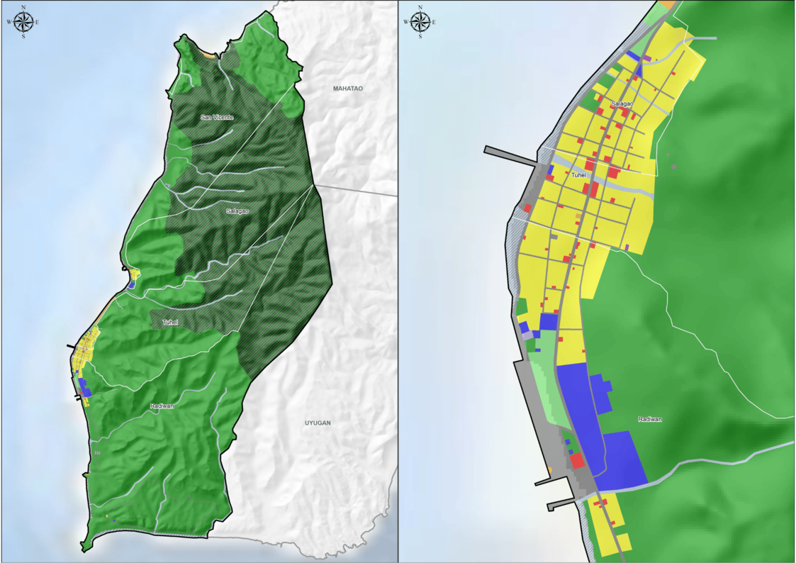
 Figures 9-10. [Top] Existing Land Use Map of the Municipality of Mahatao and [Bottom] a Detailed View of Its Land Use Features
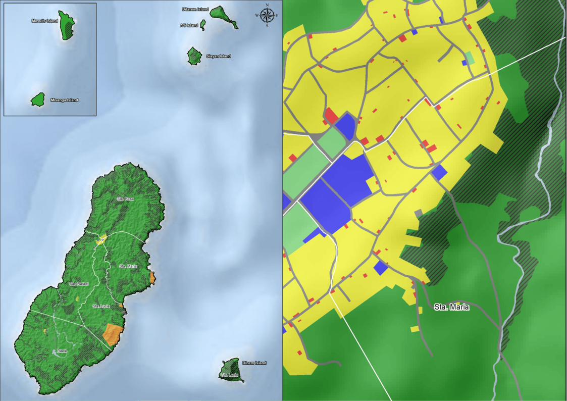
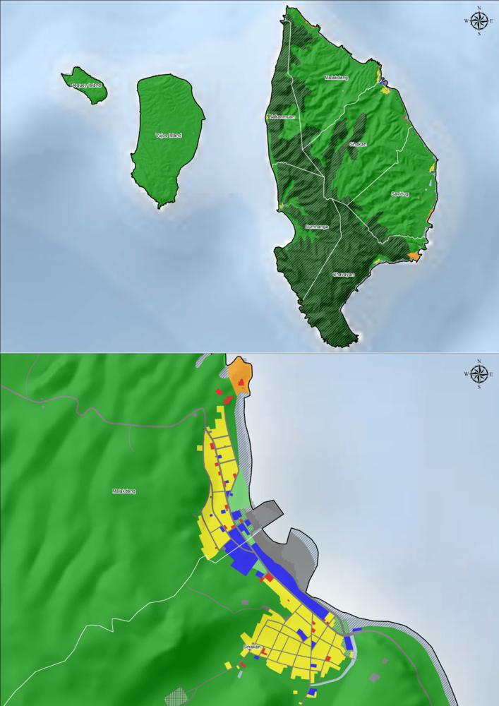 Figures 11-12. [Top] Existing Land Use Map of the Municipality of Sabtang and [Bottom] a Detailed View of Its Land Use Features
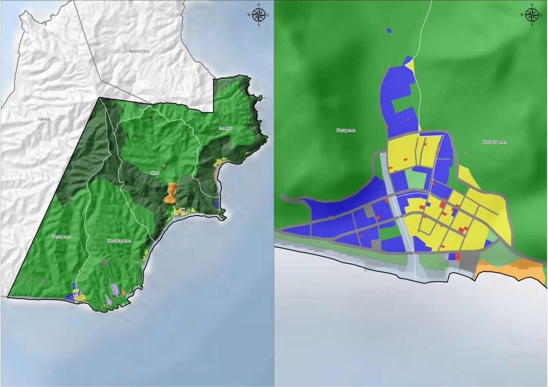 Figures 13-14. [Left] Existing Land Use Map of the Municipality of Uyugan and [Right] a Detailed View of Its Land Use Features
Toward Risk-Informed Island Planning
The GIS and ELU mapping activities show that building resilience is not only about technology but also about collaboration, participation, and the sharing of knowledge. By bringing together spatial science and the lived experiences of Batanes communities, the project highlights that effective disaster risk reduction begins with understanding both the land and the people who depend on it.
Through these collective efforts, Batanes moves closer to its vision of sustainable and risk-informed local development, where data, tradition, and shared learning come together to strengthen its island communities.