
By: Audrei Ybanez (Hazard Assessment Team, NOAH Center), Dainty Clarice Rabang (Education Division), Julian Grageda (Hazard Assessment Team, NOAH Center), Marc Forneste (Hazard Assessment Team, NOAH Center), Richard Ybanez (Education Division), and Zebedee Aguas (Hazard Assessment Team, NOAH Center)
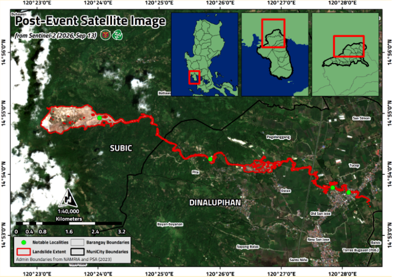
The period of intense Southwest Monsoon (Habagat) rainfall on 28–29 August triggered a large landslide last August 30, 2026 in the upper portion of a watershed along the Zambales Range in Barangay Batiawan, Subic, Zambales. The large volume of material mobilized from the mountain slopes traveled several kilometers downstream and eventually contributed to flooding in lower-lying areas. The landslide was visible from the Subic–Clark–Tarlac Expressway (SCTEX) because of its scale and the extent of exposed material on the mountainside.
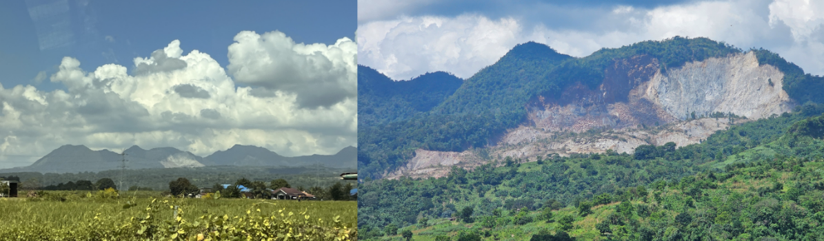
Residents reported hearing a loud noise at the time of the landslide. This was followed by reports of flooding and sediment-laden debris affecting downstream communities in Dinalupihan, Bataan. The event transported large volumes of newly mobilized sand, gravel, and boulders along the river system. Several structures, such as bridges and houses near the river in Brgy. Pita, Dinalupihan, were damaged or buried by deposited sediments.

In response to a request from the Office of Congresswoman Maria Angela Garcia, the University of the Philippines Resilience Institute (UP RI) conducted a field assessment of the event—now referred to as the Dinalupihan Landslide—on 15 September 2026.
The assessment was undertaken by the UPRI NOAH Center Hazard Assessment Team, together with the UPRI Education Division. The team conducted key informant interviews with affected residents and local officials, drone-based surveys, and ground field observations.

The joint survey was conducted in coordination with the Office of Congresswoman Maria Angela Garcia; the Bataan Provincial Disaster Risk Reduction and Management Office; the Dinalupihan Municipal Disaster Risk Reduction and Management Office; officials and community members of Barangays Batiawan, Subic and Pita, Dinalupihan; and the Mines and Geosciences Bureau Region III.
The assessment aims to document the landslide source area, characterize the affected river channels and downstream deposits, and identify areas that may remain exposed to landslide- and debris-flow-related hazards. Information from the drone survey, field observations, assess potential hazard pathways, and help identify safer areas where residents may temporarily relocate or seek refuge during future landslide and debris-flow events.
The assessment seeks to address key questions: What conditions contributed to the landslide? How did the landslide material move through the watershed? Which downstream areas may be affected by future sediment-laden flows? The findings will support evidence-based decisions for affected and at-risk communities, including the identification of appropriate risk-reduction and recovery measures.
Beyond the immediate assessment, the investigation will contribute to the scientific understanding of landslides in volcanic and mountainous terrains. The Subic–Dinalupihan area provides an important opportunity to examine how rock type, slope geometry, watershed conditions, rainfall, existing geological structures, and other triggering factors interact to produce large slope failures and downstream sediment hazards.
This work reflects the University of the Philippines’ public-service mandate: translating research into information that can support governance, disaster risk reduction, and the protection of communities. By improving understanding of local hazard processes, government agencies and communities can develop context-specific, sustainable interventions that reduce risk and help save lives.
To learn more about the Dinalupihan landslide and the associated hazard assessment, please refer to the NOAH Open-File Report. The series provides rapid access to preliminary scientific findings, maps, datasets, and technical information that support ongoing hazard assessment and disaster risk reduction efforts (https://resilience.up.edu.ph/publications/noah-open-file-reports/).
–
References:
AMF Lagmay, JMB Grageda (2026) The August 2026 Rainfall-Triggered Rockslide-Debris Avalanche–Debris-Flow–Flood Cascade on the Flank of Balikabok Volcano, Zambales Range. Vol. 15 (2026), No. 12, pp. 101–108, ISSN 2362 7409. https://doi.org/10.5281/zenodo.22803827
JMB Grageda, RL Ybañez, AA Ybañez, DC Rabang, ZT Aguas, MJ Forneste, C Malaiba, AMF Lagmay (2026) Geometric Characterization and Mobility Assessment of the September 2026 Balikabok Landslide Vol. 15 (2026), No. 16, pp. 150–155,ISSN 2362 7409